


Oct 2: Updated
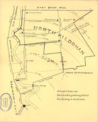
Source: Manitoba Historical Maps
A couple of decades-in-the-making projects have created a whirlwind of development activity in North Kildonan not seen since the 1970s.
A couple of decades-in-the-making projects have created a whirlwind of development activity in North Kildonan not seen since the 1970s.
For the past thirty years, aside from the addition of single-family homes along the south side of Springfield Road and in the north east, noticeable development in N.K. has usually been limited to the McDonald's at Whellams Lane which gets torn down every few years and rebuilt in the latest McDesign.

That's the way it has been in North Kildonan since its inception in 1925. In fact, it broke away from the R.M. of East Kildonan over the issue of development, choosing instead to retain its rural, agricultural ways. (For more on the history of the R.M. of North Kildonan.)
Despite this aversion to development, N.K. couldn't keep the lid on the post-war population boom. Through the 1950s its population more than doubled, from 3,200 to over 7,000. New schools had to be built and the demand for better housing options tipped their hand. In the late 1950s its largest subdivision, Silver Heights, came into being. Not long after, River East Collegiate came along.

January 8, 1972 (source)
The only time in its history that North Kildonan saw a biggerconstruction frenzy was between 1970-72, in preparation for the R.M. of North Kildonan joining the "Unicity" of Winnipeg. Those three years saw the transformation from a sleepy rural community into, well, a slightly less sleepy suburb.

March 18, 1972, Winnipeg Free Press
In that time dozens of new projects were built, not to mention the related infrastructure work required to support it. Here are just a few examples: Donwood School; a 65 townhouse development between Springfield Road and Donwood along Raleigh; Riverside Plaza at 1660 Henderson (plus other Edison Development apartment blocks along Henderson and a newly-created Valhalla Drive); the Nor-Villa Motor Hotel and the above mentioned River East Plaza !Here are someo f the big N.K. Developments of late:
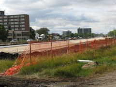
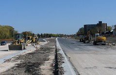
The most noticeable and expensive of the developments has been the Chief Peguis Trail Extension which has turned that empty, lazy stretch of land along Douglas Avenue into a Berlin Wall between north-North Kildonan and south-North Kildonan.

This "inner ring road" has been on the books since the 1968 Winnipeg Area Transportation Study (WATS). In 1990 the first stage, which included the Kildonan Settlers Bridge, was built and it was just a matter of time before the rest fell into place.
Rothesay looking west toward Henderson (Aug 2011)
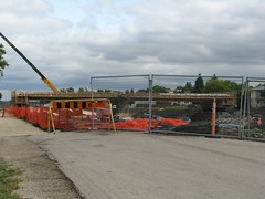
Rothesay Street Overpass (Aug 2011)
Henderson looking East toward Rothesay (Oct 2, 2011)
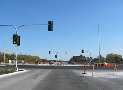
Chief Peguis Trail (at Henderson) looking east toward Rothesay (Oct 2, 2011)

May 27, 1972, Winnipeg Free Press

Source: Development plan submitted to City of Winnipeg, 2010
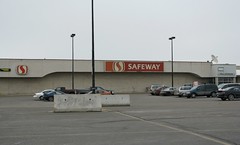
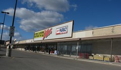
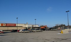
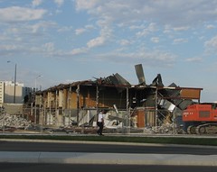
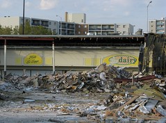
The other project of note is the redevelopment of River East Plaza.
The original 'mall' opened in May 1971 with a Kmart and Safeway as anchor tenants and was the 'retail mecca' for the area. Sure, there was the circa 1961 Springfield Heights Shopping Centre on Rothesay and the circa 1980 McIvor Mall further up Henderson but for the big supermarket and an actual department store, River East Plaza was it !
Though many of the smaller tenants, Arnold's Card shop, a hairdresser and a dry cleaner, began vacating in the 1980's in preparation for changes to the mall, nothing ever happened. The CIBC moved from the mall to a stand-alone location in the parking lot just five or so years ago. The Zellers' lease was not renewed and closed in fall 2010 and that left Safeway as the only tenant.
October 2010
March 2011

August 2011
October 2, 2011
Related:
North Kildonan History Daniel Mac Alumni Association
R. M. of North Kildonan Manitoba Historical Society
River East Collegiate turns 50 West End Dumplings
7 comments:
Great post. Old girlfriend lived in 1700 block on Henderson in the 80's & I well remember the Nor-Villa for a host of bizarre reasons. A strange place unto itself, its clientele spoke volumes about how a nascent suburban youth culture in Winnipeg (removed from outside influences) tried to define & mark its territory as distinct from that being laid out by people in Transcona, Pembina Hwy, etc.
Ah, memories. Great post, just one question. The Peguis Trail plans call for crossings at Rothesay and Gateway in addition to Henderson & Lag., are they not being built now?
I've added some more pics as of today. Tarmac on the trail and Safeway almost gone !
@ Arse - ah, the Villa. I have good, odd memories of the palace as well !
@ Expat - I've captioned the pic of the Rothesay overpass in the updated post. It is apparently a few weeks behind schedule and will open in November. The Lagimodiere one looks almost ready to go. Not sure about Gateway.
They still have to install the sound berms so I don't think it will open until that is all done.
Hi
As a former Cheriton Ave resident, was wondering if anyone knew the name of the street that was renamed Brazier in the 50s/60s?
Also at 1961 or 62 Canadian Indoor Track meet at the armories(?)3 top female high jumpers were in an article in Wpg Free Press. Does anyone have ideas how to access a copy of the article?
Thanks for any help.
Hi Anon. Brazier was initially Robert Street, then Rodent Street. http://westenddumplings.blogspot.com/2021/05/how-elmwoods-rodent-street-became.html
Hi Christian. I'm curious if you know when exactly the Bergens cutoff hill was removed along the south side of Springfield Road to make way for the addition of single-family homes. I grew up on Arby Bay close by and am trying to figure out when that happened. The hill that used to be there provided the best tobogganing spots for us growing up. My guess is the 70s sometime?
Wow, thanks for this. I was wondering if you knew what the name of Graduate Path was originally? I don't recall when it was changed, sometime in the late 90s I think?
Lydia, I believe the Bergen Cutoff tracks and hill were removed in the early to mid 1980s.
Post a Comment