


This is part one of a three-part series on the history of Burnell Street in Winnipeg. I am looking at the section from Portage Avenue north to Ellice.
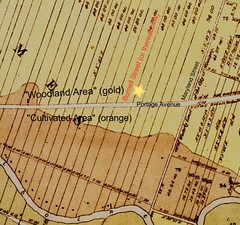
1874 map (click for source)
When the City of Winnipeg was incorporated in 1873, the “West End” east of Maryland Street (then called Boundary Road) and north of Portage Avenue not part of it. It was known as the Parish of St. James and consisted of a series of narrow lots doled out and /or sold off over many decades by the HBC.
The dividing line for the lot system is what we now call Portage Avenue, which started out as a cart trail because it was a sort of “no man’s land” in between the private properties.
As the lots north of Portage had no river access, you couldn’t farm on it, nor could it support much commercial or residential development. As a result, it was mostly pasture land dotted with the odd dairy operation or horse stable.
Even after the boundary of the city was extended to St. James Street in 1882, for the better part of two decades stayed much the same. There was a small aboriginal settlement along Home Street that was moved there from Sherbrook Street when the boundary shifted. Also, as Portage Avenue developed into a major road, industrial sites such as scrap yards, carriage repair shops, lumber yards, dairy operations, commercial stables and an abattoir set up along it.

Burnell Street was created in 1895-96. Some accounts say that the street is named for Colin H. Burnell, an Oak Lake MB farmer who rose to become head of the United Farmers of Manitoba, then the first president of the Manitoba Wheat Pool. Colin, however, would have been about 15 and living near Oak Lake at the time the street was named. I also cannot find any Winnipeg references for his father Henry. This makes Colin the unlikely origin.
There were other prominent Burnells around, though none appear to have a connection to the St. James area or with land development. Edward Burnell of the Westbourne MB area served on a number of area councils and was a justice of the peace. Going back further, Martin E. Burnell from the Portage area fought under Major Boulton in the North West Rebellion. Mrs. Burnell was the postmaster for St. Andrews. I lean toward Edward the likeliest namesake.


City services such as sewer, graded roads and sidewalks came to this part of the West End between in 1905 and 1906. It triggered a real estate boom as hundreds of suburban lots were carved from the pasture.
Burnell Street between Sargent and Notre Dame was part of that boom, with a similar level of development as most other West End streets. Burnell from Portage to Ellice, however, had a different path. There, the land was sold off in one, two and three acre lots, and fro many years leased out annually as pasture land or commercial garden space.
By the end of the decade, the West End's street grid had developed into what we see today. While streets like Home and Simcoe were crammed with middle class homes, Burnell only had a cluster of seven homes on its east side near Portage Avenue and another 17 from St. Paul Avenue north to Ellice Avenue.
What was the reason for this lack of development along Burnell? it turns out that one man had bought up much of the land along Burnell and rathr than subdivide it, had much bigger plans!

1897 Henderson Directory of Winnipeg
By 1897 Burnell Street was a mud road with only five households between Portage Avenue and Notre Dame.
The cluster nearest Portage Avenue had an Icelandic heritage.The Einarsson family owned an acreage with a dairy operation on it. Though Helgi is listed in Henderson's, (see above), I have also found reference to Gunnar Einarsson living on that site as well. The Johnsons, Gisli and Sigriour Jonsson and daughters Ina and Elin, also lived around Burnell Street at Einarson Avenue. (Note that Einarson Avenue, which must have been named for the family that once lived by there, is spelled with just one s, whereas the family's name had two.)
The cluster nearest Portage Avenue had an Icelandic heritage.The Einarsson family owned an acreage with a dairy operation on it. Though Helgi is listed in Henderson's, (see above), I have also found reference to Gunnar Einarsson living on that site as well. The Johnsons, Gisli and Sigriour Jonsson and daughters Ina and Elin, also lived around Burnell Street at Einarson Avenue. (Note that Einarson Avenue, which must have been named for the family that once lived by there, is spelled with just one s, whereas the family's name had two.)


1904 - 1909 ads
City services such as sewer, graded roads and sidewalks came to this part of the West End between in 1905 and 1906. It triggered a real estate boom as hundreds of suburban lots were carved from the pasture.
Burnell Street between Sargent and Notre Dame was part of that boom, with a similar level of development as most other West End streets. Burnell from Portage to Ellice, however, had a different path. There, the land was sold off in one, two and three acre lots, and fro many years leased out annually as pasture land or commercial garden space.
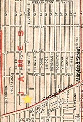
1910 map (click image for source)
By the end of the decade, the West End's street grid had developed into what we see today. While streets like Home and Simcoe were crammed with middle class homes, Burnell only had a cluster of seven homes on its east side near Portage Avenue and another 17 from St. Paul Avenue north to Ellice Avenue.
What was the reason for this lack of development along Burnell? it turns out that one man had bought up much of the land along Burnell and rathr than subdivide it, had much bigger plans!
1 comment:
This is incredibly interesting to me. I recently found out that my third great uncle, a traveling musician from Italy, lived in Winnepeg in the late 1800s and early 1900s. People called him "Mike the Fiddler" and he played music in a hotel called Pride of the West, as well as other hotels and restaurants. He died in Winnepeg in 1908. In the 1906 census, his address is listed as 6 Einarson Co. I assumed that was the abbreviation for "court," but all I find is Einarson Avenue, so I assume it's the same place - some of his neighbors on the census have theirs listed as "Einarson Street." I noticed 6 Einarson Ave would be at just about the corner of Einarson and Burnell. I'm really glad I came across your blog!
Post a Comment