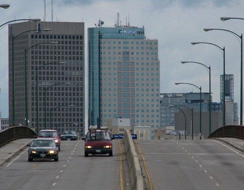
History has not been kind to the Disraeli Bridges.
In recent years some serious rot has been allowed to set in and a couple of large vehicles have driven into it which has required emergency closures, inspections, and repairs. Now, the debate is on at city hall to see what should replace it and how quickly it can be done.
Here's a look back at the bridges and the It took three decades of failed referenda, much political infighting, and even a natural disaster of near biblical proportions before it was built.
The first mention that I can find of a bridge at Disraeli Street is the "East Winnipeg Radial Commercial Highway" in the Manitoba Free Press of February 22, 1913.
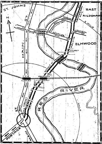
The proposed highway would have taken traffic congestion off of Main Street by running from Portage Avenue and Main Street via Rorie Street to the existing Disraeli Street. The CPR tracks would be bypassed via a subway and a the river would be crossed with a bridge to connect Disraeli Street and Kelvin Road (now Henderson Highway).
The Radial Commercial Highway project never got of the ground.
November 1938, Winnipeg Free Press
The plan came back in the late 1930s. This map was published alongside a Free Press column by James Gray in November 1938. Gray obviously had faced some traffic woes the day he wrote the piece as the column opened:
"If Winnipeg originally had been laid out by surveyors instead of meandering cows, and if the pioneer urge to erect buildings in the most outlandish places had been squelched, Winnipeg would have little cause to worry about town planning today".
Gray would have to suffer the indignity of travelling the route for another decade as the "Kelvin-Disraeli Bridge" idea did not resurface until the late 1940s when the Metro Winnipeg Planning Commission released its first 'major thoroughfare plan' in 1947.
In January 1949, the city put the Kelvin-Disraeli Bridge project on the books and began the necessary planning. The final approval would be left up to voters in a money referendum.
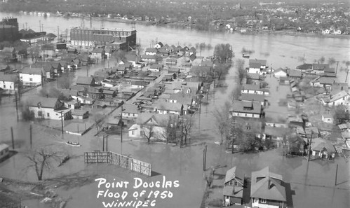
It was during the final stages of the due diligence process for the Kelvin-Disraeli Bridge that the 1950 Red River flood intervened. Above is a flood photo of the area where the bridge now stands, (you can see the Rover Street Power Station near the top left.)
The city was faced with a massive repair bill for infrastructure damaged or destroyed in the flood and there was no appetite to take on new projects. The plan went back on the shelf.
October 25, 1955, Winnipeg Free Press
The Kelvin-Disraeli Bridge project was eventually revived and in October 1955 a money referendum to approve the borrowing of $4.9 million to build it was rejected at the polls. (It won slightly more than 50% of the vote but 60% was the mark needed.) The city tried again, unsuccessfully, in 1956. A third vote in 1958 proved the charm and the project got the go-ahead from voters. The second river span built in the city since 1917 was about to become reality.
There were two significant changes made to the project's original plan. First of all, it became two bridges rather than the originally envisioned subway under the tracks and bridge over the river
The approach route was also changed. Rather than travelling from Portage and Main via Rorie Street to the bridge approach, Main Street became the main entry point with a turn off at James Street. (The current Main Street and Alexander Avenue approach was not approved for construction until 1966.)
Commemorative sign for the bridges
UPDATE: The bridge that took almost 30 years to get built will soon be coming down.
The Disraeli's future was
decided at
the September 24, 2008 council meeting. The option chosen was a $140 million pair of bridges the same size as
the existing ones (1.1 km in length) that would reuse the existing pillars in the river portion. The
site will be closed for 16 months while the bridges are rebuilt.
Update October 2009: Due to a campaign by neighbouring businesses and residents against the prolonged closure, the city and province reached an agreement to spend another $60m to allow part of the bridges to remain open throughout the construction period.
Update October 2012: The new Disraeli Bridges opened to traffic on October 19, 2012. A ceremony was held on the grounds of Argyle Alternative High School for the $195 million project. An active transportation bridge east of the river portion of the bridge will open in 2013.
Related;
My photo album of the Disraeli Bridges
Disraeli Bridge Project City of Winnipeg
Deal reached on Disraeli bridge CBC News, Oct. 2009
Disraeli Bridge condition questioned CBC News, Jan. 2012
Disraeli Bridge not unsafe: city Winnipeg Free Press, Jan. 2012
Disraeli set for Demolition over weekend CBC, June 2012
New Disraeli Bridge opens CBC News Oct. 2012
Disraeli Bridges Active Transportation Bridge now open City of Winnipeg


1 comment:
I shudder to think that there's no one watch dogging this project. I live in "Elmwood landing" and the construction has begun. So far, only prep work but already the big tree and park bench that was so delicately spared during the bank shoring up process was unceremoniously brought down today. I was told this spring that tree would be spared. They will just tell you whatever they want just so you'll go away and no cause any trouble. I worry about Elmwood landing...it's going to be held hostage for the entire time of construction.....equipment, traffic, noise, isolation.
Post a Comment